Tag Archives: Urban Escape Vehicle

Best Friends; Maqui Cave; Little Hollywood (Hitch-N-Post RV Park – Kanab, UT)

We did a lot of running around again today (Saturday), so brace yourself for lots of pictures.  Remember – this blog serves the dual purpose of being our personal ‘photo album’ to look back on in our later years.  Plus – You know what the say; “A picture is worth a …”

We left little dog “Coach” in the Coach and headed over to the Best Friends Animal Sanctuary (←link here) a few miles north of Kanab.  We heard it was best to not bring a pet along on the sanctuary tours.

IMG_3802
Sign on the side of the highway for the Best Friends Animal Sanctuary.

A couple of Quick Facts from their website: best friends.org

In 1984, the founders of Best Friends Animal Society break ground on their no-kill animal sanctuary in Kanab, Utah. It becomes the nation’s largest no-kill sanctuary and Best Friends becomes the flagship for the no-kill movement.

Nearly 30,000 people visit every year to meet the animals and tour what has become the nation’s largest no-kill sanctuary for companion animals.

The sanctuary is on 3,700 acres (15 km2) with an additional 33,000 acres (130 km2) leased from the United States Bureau of Land Management near Zion National Park, the Grand Canyon’s North Rim, Bryce Canyon National Park, and Lake Powell.

IMG_3804
Sign near the Welcome Center.

There was only one problem when we arrived – the sanctuary only has four “General” tours daily and they were already full 🙁

They also have a number of “Special” tours, i.e., Parrot Garden; Wild Friends; Horse Haven & Piggy Paradise; Bunny House; Behind-the-Scenes; etc.,  but these tours also require prior coordination and are mostly early-morning tours.

So we signed up as “standbys” for the last “General” tour of the day at 2:30 PM and left to go check out some other local attractions.


We went north on 89 for a mile or so and came upon the Moqui Cave.

IMG_3849

IMG_3851

The Moqui Cave was once used by Anasazi people as a shelter or food store, according to archaeological digs in the area.  It was rediscovered by white settlers in the 19th century, and served as a speakeasy in the 1920s during Prohibition.  In 1951, the cave was purchased by Laura and Garth Chamberlain, who opened a tavern and dance hall the following year, and it became a tourist attraction and museum.  It currently contains a substantial rock collection, including many ultraviolet-fluorescent minerals, fossils, pottery, spear points, American Indian artifacts and art, dinosaur tracks (estimated to be over 140 million years old), and displays about the Anasazi.  There is also display about the Ancestral Puebloan and a gift shop. (ref: Wikipedia®)

IMG_3822 

IMG_3816

IMG_3817

IMG_3818

IMG_3819

IMG_3820

IMG_3821

IMG_3824

IMG_3825

IMG_3839

IMG_3826

IMG_3830

IMG_3827

IMG_3831

IMG_3832

IMG_3833

IMG_3835

IMG_3836

IMG_3837

IMG_3840

IMG_3842

IMG_3841

IMG_3843

IMG_3844

IMG_3845

IMG_3846

IMG_3847

IMG_3814

The Moqui Cave was pretty cool and the entrance fee was a reasonable $5 per person.  And – we got a $1 military discount off that.  Worth the stop if you’re in the area.  Stilla wasn’t even  claustrophobic which is usually a concern at places like this.


We headed on up 89 (north) to the town of Orderville…

kanab-area-map

where we passed by the cool looking “Rock Stop”…

IMG_3858

and then we found the German Bakery that a couple people told us about:

IMG_3853

IMG_3857

IMG_3852

IMG_3854

IMG_3856

IMG_3855

We enjoyed a quick lunch and Stilla stocked up on bread and a couple sweet treats.  The lunch was good and I stole one of the kirsch tortes from the “to-go” bag before we left.   No dessert for me later. 🙂


We decided to head back south so we wouldn’t be late for our 2:30 tour at the Best Friends Animal Sanctuary.  But first, I wanted to check out Coral Pink Sand Dunes State Park (←link).

IMG_3859
View heading south on 89 going towards Kanab.

The sand dunes are about 15 miles off 89 west of Kanab.  We figured we had enough time to check it out for future reference before our sanctuary tour.  You never know – we might want to bring the ATV back here sometime in the future.

We found a large parking area just before the entrance to the state park with lots of rigs, ATV’s, and other off-road vehicles.  We could see the beginning of the dunes in the distance.  Since we were short on time and didn’t want to hassle with an entrance fee to just check out the park, I just snapped a couple pics:

IMG_3860

IMG_3861

We’ll definitely have to come back here with the ATV.  The website says that 90% of the dunes are available for riding.  Day use fees are only $8 and the main campground is $20.


We got back to the Best Friends Animal Sanctuary just in time for the 2:30 tour and found out that our “standby” status was upgraded to “full-tour members” 🙂

IMG_3807

IMG_3870
Entrance to Best Friends off Hwy 89.
IMG_3871
Entrance to Best Friends off Hwy 89.

We had to wait for some wild turkeys to cross the road on the way to the Welcome Center.

IMG_3872

IMG_3873

The Best Friends Welcome Center.

IMG_3899

IMG_3901

IMG_3900

IMG_3902

IMG_3903

IMG_3904

We watched a documentary in the theatre with the other members of our tour group.

IMG_3874

And then our group was split up into two shuttles.

IMG_3875

This place is huge… our tour-guide/driver took us around the sanctuary and pointed out the many buildings.  We stopped at one of the areas where they keep the cats:

IMG_3876

IMG_3877

In one of the mesh-enclosed outer rooms, the cats even had ramps so they could hang out in the rafters.

IMG_3878

IMG_3879

IMG_3880

IMG_3883

IMG_3884

These cats are currently up for adoption.

IMG_3886

The only other place we got to stop at was one of the nice octagon-shaped buildings to visit the older dogs:

IMG_3887

IMG_3888

IMG_3889

We got to visit with a few of the dogs after a tour of the kennels.

IMG_3891

There are lots of volunteer opportunities here.  The sanctuary is home to around 1,700 animals.  They even have guest cottages and an RV park for guests/volunteers.  We toured the RV park on our way back out but only saw two sites along a dirt loop.

IMG_3892

Some ponies.

IMG_3895

They even have a couple nice pet cemeteries here for the animals that passed (due to sickness, accident, or other natural causes).  They don’t put any animals to sleep here at the sanctuary unless it’s for humane reasons.

IMG_3896

The canyons and area inside the sanctuary grounds have been used as the backdrop for some “B” western movies.  “Headin’ ’em off at the pass!” was filmed at Ambush Pass on the dirt road through the sanctuary.  The iconic scene, “Hi Ho Silver Away!” from “The Lone Ranger” was filmed here along with scenes from “One Little Indian” (The old barn still in use here is actually a movie set) and scenes from “The Outlaw Josey Wales.” (ref: TripAdvisor)

IMG_3897

IMG_3868

IMG_3867


After our free ~90 minute tour of the animal sanctuary was concluded we headed back into the town of Kanab to check out the Little Hollywood Museum (←link).

IMG_3969

IMG_3967

We walked through the gift shop to take the free tour of the Western movie sets behind the building.

IMG_3908

IMG_3909

IMG_3910

We watched some of the video presentation inside one of the buildings.

IMG_3911

And then we walked through the movie sets as it started to drizzle again.

IMG_3916

IMG_3915

IMG_3921

IMG_3919

The “Outlaw Josey Wales” homestead set:

IMG_3943

IMG_3918

IMG_3944

IMG_3945

IMG_3941

Barn used in the movie “Outlaw Josey Wales”:

IMG_3925

IMG_3926

IMG_3927

Tack & Feed building from “Black Bart”:

IMG_3929

IMG_3930

IMG_3931

IMG_3933

IMG_3934

IMG_3935

IMG_3936

IMG_3937

IMG_3938

IMG_3939

IMG_3946

IMG_3950

IMG_3952

IMG_3955

IMG_3956

IMG_3958

And what tour is complete without a visit to the gift shop !?!:

IMG_3959

IMG_3960

IMG_3961

IMG_3962

The Little Hollywood restaurant (←link).

IMG_3963

IMG_3964

IMG_3965

IMG_3966

We decided to call it a day and drove back through town to our site at the Hitch-N-Post RV Park.

IMG_3971

IMG_3976

IMG_3978

Today (Sunday) we’ll head on over to Saint George, UT  which brings us a little bit closer to Las Vegas, NV where we will meet our son William on the 22nd.

William just got in from Germany last night. Stilla’s excited!  He arrived in Colorado Springs with his girlfriend Jasmine to stay at our daughter Joleen’s house for a few days.  Then they’ll rent a car and drive out to Las Vegas to meet up with us later next week.

Also, my brother Steve, his girlfriend Cheryl, my Mom, and Stepdad Jim will come up from Casa Grande, AZ in week or so to meet us as well!

We’ve been to the Elks Lodge in Saint George before and are looking forward to a few days there.  Stay tuned… don’t let all the pictures scare you away 🙂


Grand Canyon North Rim (Hitch-N-Post RV Park – Kanab, UT)

On Friday the weather outlook called for rain later today, and the forecast doesn’t look good for the next three days 🙁

So much to see and do in and around Kanab, check out this website (←click here) that highlights three pages of attractions.

Here’s a brochure we got from the campground office:

IMG_3670

IMG_3669

We decided to start off by driving the Silverado over to the Grand Staircase-Escalante Visitors Center which is within eyesight of our campground.  This is the place that holds the lottery for a 6-mile hike to see “The Wave“.(← click here).

IMG_3679

This is a picture of “The Wave” below: (photo courtesy of NationalParkTourz.com)

The Wave image

In order to hike “The Wave,’ you must have a permit.  The Bureau of Land Management (BLM) limits access to the North Coyote Buttes WIlderness Area to just twenty permits per day.  Ten of the permits are available in advance by an on-line lottery that is conducted four months before the month for which the permit is sought.  The remaining ten permits are made available by lottery the day before ones intended hike.  Year round the lottery is held at the ranger station on the east end of Kanab.  The lottery for the walk-in permits takes place at 9:00 in the morning. (ref: NationalParkTourz.com)

The lottery is held behind these doors (below), we were too late to try our luck.  I don’t think my hip replacement would like a 6-mile hike anyway 😐

IMG_3676

Here’s a few more photos inside the visitors center:

IMG_3677

IMG_3673

IMG_3672

IMG_3678

We decided, that since rain is imminent for the next few days, that we would try our luck at visiting the Grand Canyon North Rim while the sun was still shining (off and on).  The other attractions that are nearer – or even in Kanab can wait until tomorrow or ?

Screen Shot 2015-10-17 at 8.12.56 AM

So we put our little dog “Coach” into the Silverado and headed south to the North Rim (~80-90 miles one-way) to try and beat the rain.

Road sign (below) as we got closer to the North Rim.

IMG_3682

We stopped at the North Rim Country Store to get some snacks because we heard the concessions at the North Rim were closed for the season and also, we forgot to pack lunch.

IMG_3690

And finally we arrived at the park entrance.  It was 80° when we left Kanab and is now in the mid-to-low 40’s.

IMG_3693

I was able to use my disabled veteran access pass to get free entry.

IMG_3694

Some of the leaves haven’t fallen off the trees yet.

IMG_3697

One of the nice campground host(s) back at the Hitch-N-Post in Kanab told us that most people only go straight to the lodge and miss out on a lot of scenery.  She recommended that once inside the park, we should take the road south to Cape Royal to see Angels Window.  So we followed the tip and drove ~15 miles to the viewpoints.

Cape Royal is the southernmost viewpoint on the North Rim, and it has the widest panorama of any Grand Canyon overlook – the great gorge occupies about 270° of the horizon, from Marble Canyon in the north, south over Palisades of the Desert, and westwards for many miles towards the main South Rim visitor area around Garden Creek. (ref: AmericanSouthwest.net)

Our first view of the Grand Canyon from the North Rim:

IMG_3702

IMG_3705

IMG_3707

IMG_3708

We finally reached the parking lot and took the path(s) to the Cape Royal Pt. and Angels WIndow viewpoints:

IMG_3712

IMG_3713
No dogs allowed 🙁
IMG_3724
Angels Window. Notice the people on top – we’ll be up there soon.
IMG_3722
Stilla in front of Angels Window at the Grand Canyon North Rim.

We chose the path on the right first to see Cape Royal Pt.  The sun was just starting to go behind some clouds…

IMG_3755

Here you can see the clouds rolling in (below).

IMG_3729

IMG_3727

IMG_3725

IMG_3730

IMG_3732

We walked back up the path after taking a lot of pictures and then went out on top of Angels Window for some more awesome views.

IMG_3759

IMG_3761

IMG_3762

IMG_3765

IMG_3766

IMG_3768
Stilla on top of Angels Window at the Grand Canyon North Rim.
IMG_3770
Rare photograph of myself – on top of Angels Window at the Grand Canyon North Rim.
IMG_3771
Stilla on top of Angels Window at the Grand Canyon North Rim.

IMG_3773

We drove back to the main road and went down to the main North Rim Visitor Center where the lodge is located.  It started raining on us 🙁

IMG_3786

IMG_3796

IMG_3787

IMG_3788

We toured the visitors center quickly… it was 15 minutes before closing time at 5 PM (Arizona time).

IMG_3790

IMG_3791

Whiteboard on the wall (below) at the Visitors Center with the weather outlook.

IMG_3792

A shot of some of the cabins situated around the visitors center.

IMG_3789

We didn’t go down to the lodge or any of the viewpoints here because it started raining heavily by now.  Here’s an information board in front of the visitors center regarding the lodge.

IMG_3794

We plugged our campground into the GPS that I remembered to take out of the RV for our trip today and headed back to Kanab through the rain.  We ended up putting about 200 miles on the Silverado by the time we returned.

IMG_3798

And that was our Friday… it’s still raining off and on this morning (Saturday) but the sun is trying to peek out.  Maybe we’ll try to visit the Animal Sanctuary and Little Hollywood today… stay tuned 🙂


Pack-Up & Travel Day (Hitch-N-Post RV Park – Kanab, UT)

We took our time on Thursday leaving Wahweap RV Park & Campground.  We loaded the Harley and bicycles, dumped and flushed the tanks, and raised the jacks to hit the road sometime between noon and 1 PM.  We drove an uneventful 70 miles on US-89 to Kanab, Utah.

Screen Shot 2015-10-15 at 10.34.54 PM

A few pictures along the route:

IMG_3115

IMG_3110

IMG_3112

We pulled into the Hitch-N-Post RV Park because our online campground searches indicated it was the most affordable of the several campgrounds in or near the town of Kanab.

IMG_3119

The nice campground owner showed us a few spots that were still available for the next two nights.  We chose one with the least amount of tree coverage so we might be able to get a satellite signal for the TV.  We weren’t successful 🙁  Oh well, we have enough recorded shows on the DVR to keep us entertained anyway.  We paid ~$65 for two nights with full hookups and 50 Amp power.

We drove the Silverado around town to familiarize ourselves with the area and saw another Alpine Coach towing a pickup in a grocery store parking lot.  I pulled into the lot and introduced myself and Stilla.   We met Van L. Dossey from Placerville, CA.  He and his wife (who was inside shopping) have been touring the area.  I told Van about our recent Lake Powell Rally and also about the upcoming Quartzsite and Lake Havasu rallies next year.  He mentioned that they had recently met Mike & Michelle Collins who were just at the Alpine SoCal Rally.  We exchanged cards.  Hopefully they’ll be able to join us in the future.

We found a chinese restaurant nearby for dinner and then walked around the campground and adjoining streets before turning in for the night.

IMG_3123

IMG_3120

This campground happens to be home to Utah’s rare white bees:

IMG_3128

IMG_3129

Cute, eh? 🙂

IMG_3127

The town of Kanab is situated in the “Grand Circle” area, centrally located among Vermilion Cliffs National Monument, Bryce Canyon National Park, the Grand Canyon (North Rim), Zion National Park, and Lake Powell. Other nearby attractions include Grand Staircase-Escalante National Monument, Coral Pink Sand Dunes State Park, the privately owned Moqui Cave, and the largest animal sanctuary in the United States, Best Friends Animal Society. (Ref. Wikipedia®)

Locals refer to Kanab as “Little Hollywood” due to its history as a filming location for mostly western movies and television series such as Stagecoach, The Lone Ranger, Gunsmoke, Daniel Boone, El Dorado, Planet of the Apes, The Outlaw Josey Wales, Sergeants 3 and WindRunner: A Spirited Journey.

Hopefully, we can check out some of these attractions while we’re in the area… stay tuned to find out.

Alpines Leave & Hanging Garden (Wahweap CG – Lake Powell Resort & Marina)

It’s been a great rally!  It was sad to see all the Alpines leave this morning (Wednesday) 🙁  There were many, many hugs and ‘see-ya-laters’.

IMG_3098

IMG_3100

Some of the Alpines passed by as we finished taking down the EZ-Up Tents, and packed up the tables and chairs to take them back to the rental place in downtown Page.

IMG_3096

This time we switched it up and put the round tables in my truck (above) and the chairs in Daves’ (below).

IMG_3103

By-the-way, is anyone missing their lawn ornament?  This one (below) was left in site 22.  Yes – we know who you are (Mike & Donna).  We were thinking about holding it for ransom.  If you want it back, just contact the Guhsés’ who may deliver it to the next rally for a fee 🙂

IMG_3104

After finishing up with the rally clean-up, Stilla and I took the Silverado to Hanging Garden.  We’ve passed by the entrance sign many times on our travels between Page and the campground.

IMG_3591

Some of the other Alpiners stopped by here during the Rally and told us it was worth seeing.  We turned just after the Glen Canyon Bridge at the sign (above) and went down the gravel road to the parking area.  When we saw that the road continued on down towards the lake after the parking area, we decided to see where it went.  Here’s the view back to the Glen Canyon Bridge from the road.

IMG_3595

The gravel road ended in another parking lot overlooking the lake.  We parked the truck and walked down closer to the lake.

IMG_3599

IMG_3597

IMG_3598

After checking out the cool rock formations, we drove back up to the Hanging Garden Trail parking area.

IMG_3601

The informational placard says it’s a 1-mile round trip.

IMG_3603

View (below) of the massive rock formation near the parking area that we had to walk around to get to the Hanging Garden.

IMG_3605

We started down the trail with a full bottle of cold water.

IMG_3607

And we kept walking…

IMG_3608

and walking…

IMG_3609

and walking.

IMG_3610

When the trail wasn’t easy to see; we just followed all the rocks lined up along the sides.

IMG_3613

Stilla posed for a picture in front of some neat looking sandstone formations.

IMG_3616

And we just kept following the rock-lined trail.

IMG_3617

We were completely alone so far on our hike and almost began wondering if should have waited for the 5 PM ranger-guided tour… what if we took a wrong turn?

IMG_3618

We pressed on and kept following the trail over hard rock…

IMG_3619

and through soft sand…

IMG_3620

IMG_3623

until we finally saw from a distance, what looked like it could be a Hanging Garden (below).

IMG_3666

We hiked up the hill towards the shady alcove.

IMG_3624

View of the lake behind us.

IMG_3630

And finally!  Here it is – the Hanging Garden.

IMG_3636

We had it all to ourselves.

IMG_3638

IMG_3646

IMG_3648

IMG_3650

I’ll bet these flowers (below) look really nice when they bloom.

IMG_3651

IMG_3652

Another view back toward the lake from the Hanging Garden (below).

IMG_3649

IMG_3655

We took a few more pictures and started our hike back to the parking lot.  Another couple finally showed up after we arrived, so we were no longer the only ones on the trail.

IMG_3658

IMG_3660

IMG_3661

IMG_3662

Our water bottle was empty by now and the sun was cooking us slowly.

IMG_3665

One last picture of the Hanging Garden on our way out.

IMG_3622

We were glad to be back at the truck where we had another bottle of water.  The Hanging Garden was definitely worth the hike.  Check it out if you’re in the area 🙂

After a stop at WalMart in Page for a few groceries, we made it back to the campground to relax for the rest of our last evening here at the Wahweap Campground.

We found David & Nicole back at their Coach – just relaxing after their tiresome tour-of-duty as wagon master(s).

IMG_3105

We’ll say our farewells before we pack up and head out this morning (Thursday) after I get this post published.  They are going to stay a couple more days to try and see some of the local sites that they didn’t have time for while performing all their wagonmaster duties.

We’re thinking about heading over to Kanab, UT today.  We heard there’s some good attractions there.  And it’s conveniently along our route to Las Vegas NV, where we want to be on the 22nd to meet our son William who’s coming in from Germany to visit for a couple/few weeks 🙂  Check back on us…


Colorado River Float Trip & Alpine BBQ Dinner- Alpine SoCal Rally Day 7 (Wahweap CG – Lake Powell Resort & Marina)

Day 7 of the Alpine SoCal Rally in Lake Powell started like most others with nice weather and an even-nicer breakfast spread.  I think it’s safe now to grade our wagon master(s) David & Nicole Guhsé on their performance – I’ll give them an A+ !  And I think everyone here would agree; they’ve set a high standard for future rally wagonmasters to attain 🙂

IMG_3080
Stilla and Nicole setting up the table for breakfast.

Fruits…

IMG_3082

Yogurts…

IMG_3083

Bagels… which David toasted on the grill per each customers request.

IMG_3084

Stilla even patted the hard-boiled eggs dry after David finished boiling them… now how’s that for attention to detail?  🙂

IMG_3086

Our last breakfast together…

IMG_3090

IMG_3091

And here’s one last look at our week-long rally agenda for your viewing pleasure:

Lake Powell Rally Schedule


After breakfast, everyone that had signed up for the Colorado River Float Trip, headed over to the Colorado River Discovery (CRD) Rafting Headquarters office in downtown Page.  Click link HERE for their website.

IMG_3348

Thirty-one of us gathered in front of the CRD office for a quick briefing from a tour-guide before we boarded the bus.

IMG_3346

IMG_3350

IMG_3352

IMG_3354

IMG_3353

IMG_3355

We all boarded the Colorado River Discovery bus.  Our box lunches were waiting for us on the bus.

IMG_3347

Our tour-guide explained how we were going to get to the bottom of the dam through a 2-mile long tunnel.

IMG_3359

There was security at the entrance to the 2-mile tunnel.

IMG_3362

We drove into the 2-mile long 22″- 6″ tall tunnel.

IMG_3363

The tunnel was dark except for an occasional side-shaft that opened to the side of the canyon to let in a little light every so-often.  This is the part that Stilla didn’t want to experience, therefore she stayed back at the campground today to hang out with our little dog “Coach.”

And here we are coming out at the bottom of the Glen Canyon Dam (below).

IMG_3371

View of the tunnel we had just came out of (below).

IMG_3374

We all got off the bus, put on hard-hats and walked down the long ramp to our waiting boats.

IMG_3379

IMG_3376

IMG_3375

IMG_3378

Here we are at the bottom of the ramp.  They split us up into two groups, each with our own boat.

IMG_3382

Here’s the group on my raft…

IMG_3388

IMG_3396

and here’s the other group heading down the river in front of us.

IMG_3384

Information on the rafts is available at the CRD website: “Colorado River Discovery utilizes inflatable, motorized pontoon rafts. Comfortably carrying a maximum of 22 passengers and piloted by an experienced guide, these rafts are ideal for navigating the Colorado River between Glen Canyon Dam and Lees Ferry, Arizona.

IMG_3389

Views of the dam and bridge from our vantage point in the raft:

IMG_3390

IMG_3391

That’s the Carl Hayden Visitors Center (below center) perched on the edge of the cliff.  We visited that on Sunday when we took the dam tour.  Click HERE for that post if you missed it.

IMG_3392

The spillway (below).  Hope no one opens that while we’re down here 😐

IMG_3393

We headed down the river.  Our destination for the day is supposed to be Horseshoe Bend.  Then we’re going to turn around and motor back up to our waiting bus again.  I wrote about our visit to the Horseshoe Bend overlook in a previous post.  Click HERE if you missed that.  We’re also going to stop along the way to check out some petroglyphs.

IMG_3407

We rounded the first bend and could no longer see the dam and bridge behind us.

IMG_3409

The cliffs were amazing to see from below.

IMG_3408

IMG_3415

We passed a little waterfall.

IMG_3417

IMG_3418

Some fishermen in a boat we passed had just hooked a fish.  We floated past quickly and didn’t get to see him pull it in.

IMG_3420

IMG_3421

IMG_3422

Alpiners – Orville & Mary Ann.  Remember them from my first posting at the Page, AZ Elks Lodge when we first got here last week?

IMG_3414

IMG_3424
Beth Cannon taking a picture. One of many.
IMG_3425
Reginald Bodeaux (on the left). One of our newest members.

We passed a couple of birds on our float, I think I heard someone say this a Great Blue Heron(?)

IMG_3426

IMG_3434

IMG_3437

Yup… those are my feet…

IMG_3438

Our boat-driver/tour-guide pointed out things along the way.

IMG_3440

IMG_3441

At times, you could see to the bottom of the river.

IMG_3444

IMG_3446

IMG_3449

We eventually floated around a bend and saw other boats beached near the petroglyph site.

IMG_3452

We pulled in next to the other boats and met up with the others in our Alpine group.

IMG_3451

We hiked a few hundred yards up a path to view the petroglyphs.

IMG_3453

IMG_3455

Group photo of the SoCal Alpine group at the Petroglyph site near Horseshoe Bend on the Colorado River.

IMG_3457

IMG_3458

The petroglyphs:

IMG_3459

IMG_3460

IMG_3461

IMG_3462

Informational placard on the petroglyphs:

IMG_3463

When we returned to the boats after viewing the petroglyphs, we found Bill Figge had just taken a dip in the river.

IMG_3464

Brrrr… I don’t think he’ll do it again soon.

IMG_3466

Yup… those are my feet again 🙂  The water is reportedly a consistent 47° because it comes from the bottom of Lake Powell through the dam.

IMG_3470

We boarded our respective boats again to head down the river a little farther to Horseshoe Bend:

IMG_3465

IMG_3468

IMG_3471

IMG_3472

And here we are coming around Horseshoe Bend…

IMG_3475

If you look closely, you can see the people at the top looking down on us from the cliff edges…

IMG_3482 (1)

IMG_3482

IMG_3485

We rounded Horseshoe Bend.  This is the view to the west.

IMG_3487

IMG_3488

IMG_3490

Shortly after rounding the Horseshoe Bend, we turned around and motored quickly back up river…

IMG_3496

IMG_3523

IMG_3524

Here’s the north looking view of Horseshoe Bend after we turned around.  The tourists are on the cliffs to the right side now.

IMG_3507

IMG_3515

IMG_3516

We motored past the petroglyph site.

IMG_3518

IMG_3521

And finally we could see the dam again.

IMG_3525

IMG_3527

Both of our boats paused below the dam for a bit while our respective tour-guides gave us a little more information about the area and answered questions.

IMG_3538

IMG_3533

IMG_3531

IMG_3536

IMG_3539

We thanked our tour-guides, disembarked from our boats, and walked back up the long ramp to the bus.  The bus took us back out of the canyon through the 2-mile long tunnel again.

IMG_3544

I highly recommend this raft trip to anyone visiting the area.  The only thing I wish we could have done, is to float all the way down to Lee’s Ferry and then bus back from there.  Remember my post about our drive to Lee’s Ferry?  Oh well, we have to save something for next time, right?  🙂

View of the bridge from above.  Our campground is on the horizon to the right in the picture below.

IMG_3553

When we retuned to the campground, it wasn’t long before it was BBQ time!  Everyone broke out their grills and set them up at our get-together site.  Do you think we have enough grills?  🙂

IMG_3559

The grills were all lined up dress-right-dress.

IMG_3561

It wasn’t long before the table was filled with everyone’s favorite dishes:

IMG_3574

And the grills were fired up:

IMG_3564

IMG_3571

IMG_3573

IMG_3576

IMG_3560

IMG_3577

IMG_3578

IMG_3580

I didn’t hear anyone complain… especially since we all cooked what we brought ourselves 🙂

Another beautiful sunset for our final day of the rally…

IMG_3581

IMG_3582

We continued socializing after dark with the help of Orville & Mary Ann’s ‘Bonfire in a Can’.  Link HERE.  Yes, we bought one too 🙂  Thanks Mary Ann!

IMG_3587

IMG_3589

And another fine Alpine Coach SoCal Rally is in the history books!

Now all we have to do is pack all this up again… uuggh 🙁  We decided to stay another day (Wednesday) to help Dave & Nicole clean up and return the tables and chairs… but I’ll save that for my next posting.

IMG_3579

Stay tuned for our next adventure…

Lake Powell Party Boat – Alpine SoCal Rally Day 6 (Wahweap CG – Lake Powell Resort & Marina)

The Alpine SoCal Rally continued on Monday with a “Free Day” – there were no scheduled events other than our usual 5 PM “Social Hour”.

Lake Powell Rally Schedule

Everyone did their own thing today.  Our ‘thing’ was to rent a party boat and cruise around Lake Powell with 4 other couples.  The couples were: David & Nicole Guhsé, Bill & Patti Figge, Norm & Beth Cannon , Bob & Connie Bowers, and of course, ourselves.  Our wagon master for the Rally, David Guhsé arranged the rental.

We left for the Antelope Point Marina (←link here) at 7:15 AM.

IMG_3115

IMG_3121

Everyone packed lots of food, snacks, and drinks.  The Marina staff piled our bags into the shuttle service vehicles that were waiting for us at the entrance.

IMG_3116

IMG_3118

IMG_3123
(L to R) Nicole, Patti, Beth, and Connie.

The staff transported us down to the docks.

IMG_3124

IMG_3128

Here’s David securing the rental boat for us at the rental office / boat.

IMG_3132

We walked down the dock between all the house boats and party boats to find our ride for the day.

IMG_3133

And here it is.

IMG_3136

We inspected the boat.

IMG_3134

IMG_3135

We got operating instructions…

IMG_3141

and some location tips.

IMG_3143

IMG_3147

It even comes with a water slide 🙂

IMG_3149

We maneuvered away from the marina…

IMG_3150

past the other rentals and private house boats…

IMG_3154

and out into the lake we go…

IMG_3158
(L to R) Bob, David, and Bill.

IMG_3157

Norm made awesome Bloody Mary’s with all the fixin’s to get us started.  Mine was a virgin 😉

IMG_3155

IMG_3159

Looking down from the upper deck.

IMG_3161

Our route for the day would take us into Navajo Canyon.

IMG_3162

Screen Shot 2015-10-12 at 11.16.40 PM


Now take a deep-breath and follow along on our tour with this collection of photos:

IMG_3167

IMG_3168

IMG_3171

Stilla on the upper deck.

IMG_3172

IMG_3174

IMG_3179

IMG_3180

IMG_3186

IMG_3195

Aaah… Life is Good!

IMG_3183

IMG_3196

IMG_3197

IMG_3198

IMG_3199

IMG_3200

We stopped a few times throughout the day to jump in the water.  Here’s the first time I went  in.

IMG_3206

Bill on the water slide.  I took my turn next.  Bills wife Patti also took the challenge.

IMG_3207

Bill and I in the water.  It wasn’t cold at all – quite pleasant.

IMG_3208

IMG_3209

IMG_3214

It wasn’t long before we had pre-lunchtime snacks spread out on the kitchen island.

IMG_3217

IMG_3222

IMG_3223

David & Nicole Guhsé.

IMG_3226

Rare photo of us.

IMG_3231

IMG_3232

IMG_3233

David and Bill lounging on the upper deck.

IMG_3234

IMG_3237

IMG_3240

Norm takes a turn at the helm.

IMG_3241

And Bill takes his turn.

IMG_3243

IMG_3245

IMG_3247

IMG_3249

IMG_3250

IMG_3253

Stilla on the upper deck.

IMG_3258

IMG_3259

IMG_3261

IMG_3263

IMG_3265

Stilla lounging on one of the bench seats.

IMG_3272

IMG_3275

We stopped again for another swim.  A couple of the girls got into the water.

IMG_3276

IMG_3279

I swam over to a rock island (below).

IMG_3278

Bill joined me on my rock island.

IMG_3281

We carefully picked our way back off the island and into the water.

IMG_3283

And then we fired up the BBQ and cooked hot dogs.  We also reheated some fried chicken and wings.

IMG_3287
(L to R) Stilla, Connie, Bob, and Patti.

Bill really dressed up his hot dog… it was worth a picture.

IMG_3285

Norm & Beth Cannon.

IMG_3291

IMG_3294

IMG_3293

IMG_3300

IMG_3302

IMG_3307

There was lots of pointing going on all day by pretty much everyone… the scenery was magnificent.

IMG_3310

IMG_3312

IMG_3313

IMG_3316

Bill and I jumped in the water one last time and swam over to the cliff edge.  Why, you ask?  Because we could.

IMG_3317

IMG_3318

We headed back to the Marina to meet our 4 PM rental return deadline.

IMG_3326
David, Bob, Stilla.

IMG_3328

Check out this triple-decker with two water slides.

IMG_3320

View back up to the Marina office from the docks.

IMG_3327

We pulled into the fuel station to top off our diesel tank at exactly 4 PM.  Our fun-time was over 🙁

IMG_3330

What a great day!  After tallying up the fuel costs and splitting the rent for the day, each couple paid ~$130.  Not bad for a full day of fun, eh? 🙂

We got back to the campground just in time for “Happy Hour”.

IMG_3334

Everyone we talked to had a great “free day”.  Some couples went fishing, others went hiking, etc.,

IMG_3332

When the sun went down, Orville & Mary Ann demonstrated their Bonfire in a Can.  Don’t forget to check out the link.

IMG_3335

IMG_3337

IMG_3339

IMG_3341

IMG_3342

And so ends another fine Alpine Coach Rally day!  Stay tuned tomorrow for a recap of our Colorado River Float Trip 🙂


Glen Canyon Dam Tour – Alpine SoCal Rally Day 5 (Wahweap CG – Lake Powell Resort & Marina)

Day 5 of our Alpine SoCal Rally at Lake Powell consisted of a tour of the Glen Canyon Dam.

IMG_3078

The tour of the Dam was not an organized “pay-in-advance” tour like the other activities during this rally.  Anyone who wanted to go, simply went over to the Visitor Center at their convenience during the day and paid the $5 entrance fee.  Although, most people found out that the earlier they went – the better chance they had of getting on a tour.

Lake Powell Rally Schedule

I left a little after 8 AM on the Harley and arrived by 8:15.  This was still too late to get on the first tour of the day, so I had to hang-around inside the Visitor Center and wait for the 9:30 tour.  Some of the other Alpiners at our Rally weren’t able to get on that tour, so they made plans to do it later, or on another day.  Stilla decided not to go on the tour at all and stayed back at the Coach with our little dog “Coach”.  She was afraid the elevator or small passageways would be too claustrophobic for her.

IMG_2992

Here’s a picture of the Carl Hayden Visitor Center which is also the Glen Canyon Dam Tour entrance.

IMG_3086

The Glen Canyon Bridge:

IMG_2997

Inside the Visitor Center:

IMG_3076

IMG_3077

The lobby had an awesome terrain model of the Lake Powell area:

IMG_3003

IMG_3002

I watched one of films that was running in the auditorium until they announced the 9:30 tour.

Everyone had to go through airport-style screening and then we got on the elevator to take us to the top of the dam.

IMG_3087

Once we got on the top of the dam, our tour-guide showed us one of the original concrete buckets used during construction.

IMG_3010

IMG_3011

Follow along on the rest of the tour:

IMG_3013

IMG_3014


IMG_3017

Looking down at the spillway.  Notice the tiny blue rafts in the picture below, we plan on taking one of those for a raft trip on Tuesday.

IMG_3018

IMG_3012

IMG_3020

IMG_3019

IMG_3022

IMG_3023

IMG_3026

IMG_3029

IMG_3032

IMG_3034

Going down inside the dam:

IMG_3031

IMG_3037

IMG_3038

IMG_3039

IMG_3044

View of the Visitor Center from the bottom of the dam.

IMG_3049

IMG_3051

IMG_3054

IMG_3058

IMG_3060

IMG_3064

Back on top of the dam, heading back to the Visitor Center.

IMG_3068

I saw this flotation ring cabinet on top of the dam… Good thing we didn’t have to use this, eh?

IMG_3070

Little lizard running around on top of the dam.

IMG_3071

IMG_3075

I brought Stilla back later for a tour of the Visitor Center and then we rode around town on the Harley for a little while.  Lots of fun,

Back at the campground, there was a gathering for Jim Archer’s birthday… ice cream and cake, yummy!

IMG_3090

IMG_3091

IMG_3092

Happy Birthday Jim!  Jim is in the center of the pic below, and on the left in the pic above.

IMG_3095
Jim Archer.

IMG_3096

IMG_3098

IMG_3100

IMG_3101

IMG_3102

IMG_3104

Later on, we all gathered again at our get-together site for “Social Hour” which went long… I think we socialized for several hours…

IMG_3106

IMG_3109

Alpine ladies arrive together for “Social Hour”…

IMG_3111

IMG_3112

Another great day with the Alpine SoCal group… check back tomorrow to see what we get into 🙂


Gearhead Session & Dinner Cruise – Alpine SoCal Rally Day 4 (Wahweap CG – Lake Powell Resort & Marina)

Saturday started off with yet another great breakfast spread courtesy of our wagonmaster(s) David & Nicole Guhsé.  They’re still on track to receive an A+ grade for their performance so far 🙂

IMG_3064

Our rally schedule for the day called for “no organized day time activity” until our Dinner Cruise aboard the Canyon Princess at 5 PM.  Agenda below:

Lake Powell Rally Schedule

However, before we did nothing for the day – we set up an impromptu “GearHead Session” after breakfast.

IMG_3067

A “GearHead Session” is simply a forum for members to discuss anything related to our beloved Alpines – usually of a mechanical nature.  There is a always a wealth of information to be gleaned from our members.  Subjects discussed during the session included, but were not limited to; tow bars, tow bar breakaway switches, receiver hitches, dual-pane window fogging, lubricants and sprays for steps & slideouts, water tank dump valves, and more.  It was a good session.

The rest of the day was pretty much a hang around do-nothing day that I used to finish up yesterday’s blog post.

At 4:30 PM all the Alpiners headed over to the Marina to get ready for our scheduled dinner cruise.

IMG_2895

A couple of our members showed up in the exact same shirt which got a good laugh.

IMG_2897

We hung around in the Lodge lobby until it was time to go down to the dock.

IMG_2900

IMG_2902

That’s our ship on the lower left in the picture below.

IMG_2896

Some of us took the courtesy tram down to the ship…

IMG_2903

while others walked down…

IMG_2904

IMG_2905

and here she is – the Canyon Princess:  The website says the following about this tour: While relaxing aboard the Canyon Princess, you will enjoy the breathtaking sunset on Lake Powell. This dinner cruise combines spectacular Wahweap Bay scenery with a delicious dining experience. The Canyon Princess Dinner Cruise includes a delightful menu made up of salad, breads, a variety of entree options, and choice of dessert. Your favorite beverage is available for purchase at the bar. This two-hour dinner cruise aboard the Canyon Princess is sure to provide you with special memories of your trip to Lake Powell.

IMG_2906

We boarded the ship for our two-hour tour… uh oh, did I say two-hour tour?  Hmmmm… sounds familiar somehow 🙂

IMG_2912

Lots of carp and some stripers were hanging out around the dock.

IMG_2909

IMG_2910

We were all seated in the dining area and pretty much had the entire boat to ourselves except for a few other couples.

IMG_2913

IMG_2914

IMG_2915

IMG_2916

IMG_2917

IMG_2921

Our menu:

IMG_2925

The dinner was great!

Now – enjoy some pictures of our evening dinner cruise:

IMG_2922

IMG_2923

IMG_2926

IMG_2928

IMG_2929

IMG_2930

IMG_2931

IMG_2932

IMG_2933

IMG_2934

IMG_2937

IMG_2940

IMG_2941

IMG_2946

IMG_2947

IMG_2948

IMG_2949

IMG_2950

IMG_2951

IMG_2952

IMG_2953

IMG_2954

IMG_2955

IMG_2956

IMG_2957

IMG_2959

IMG_2962

IMG_2963

IMG_2964

IMG_2966

IMG_2970

IMG_2971

IMG_2972

IMG_2973

We returned to the dock all too soon.  It was an awesome evening!

IMG_2976

Back at the campground we walked around the campground loop with little dog “Coach” and stopped to admire Greg & Marcy Vaughan’s light show…

IMG_3068

IMG_3071

IMG_3072

It was a warm and pleasant evening.  Later, we hung out with a small gathering of our Alpine friends outside one of the Coaches until it was time to call it a night.

Check back tomorrow for a recap of Rally Day 5 which includes a tour of Glen Canyon Dam.

Presidents; Horseshoe Bend; & Lee’s Ferry – Alpine SoCal Rally Day 3 (Wahweap CG – Lake Powell Resort & Marina)

Thursday was Day 3 of the Alpine SoCal Rally at Lake Powell and it started off with another awesome breakfast served by our Wagon master(s) David & Nicole Guhsé!  Stilla and I got up early and went over to the get-together site to help set things up.  Breakfast was a home-run and went off without a hitch thanks to the rally team.

IMG_3059

After breakfast we had our Alpine SoCal Member meeting consisting of the usual stuff; old business, new business, future rally dates, etc.,  and then we voted on the nominations for our officers which was a no-brainer because all the leadership positions, except for the president, would be filled by incumbents that (as-always) have been doing an excellent job.

And now for the big news: Since our current SoCal Chapter President (Joe Darling) has been experiencing some health issues including a recent back surgery, 🙁 he is unable to continue in this role.

Joe and Micki Darling
Get well soon Joe!

Therefore the nominating committee contacted members recently to find someone to fill the position.  Of course, no one can replace Joe – only follow in his footsteps.  I kept it to myself until now, but I was nominated and it was voted on in this morning’s meeting.  I will take over Joes’s duties beginning January 1st.  I am humbled by the chapter members confidence in me and hope I can live up to expectations and Joe’s legacy.

Lake Powell Rally Schedule


After all the meeting fuss was over, 🙂  Stilla and I took little dog “Coach” in the SIlverado and we went for a day-trip since today was a “free day” until our scheduled “La Familia Spaghetti Dinner”.

We drove back out towards the South Entrance of the Lake Powell Resort & Marina and stopped at some of the scenic viewpoints:

IMG_2665

IMG_2666

IMG_2667

IMG_2668

IMG_2669

IMG_2675

IMG_2670

IMG_2671

IMG_2672

We exited the Resort & Marina area and headed back through Page…

IMG_2677
Sign as you exit the South Entrance to the Lake Powell Resort & Marina (we turned left)

to another viewpoint at Scenic View Road:

IMG_2704

IMG_2678

We parked and walked down to the view point:

IMG_2679

IMG_2682

IMG_2684

After negotiating the many slippery steps, we got a good view of the Glen Canyon Dam and the bridge.

IMG_2688

IMG_2693

IMG_2697

Wish we could be in that boat (below) 🙂

IMG_2696

IMG_2699

We walked back up the path / steps to the parking lot.

IMG_2701

IMG_2703

In the parking lot, we met this nice couple from Germany.  They are traveling around the US and even plan on going down to Argentina!  We talked for a bit, because as most of you know, Stilla is also from Germany.  They shared their blog address with us (below) so if you’re interested, give it a look.  Once again, I have to say – we get to meet the nicest people in the RV world 🙂

IMG_2706 IMG_5558

We moved on over to Horseshoe Bend.  Here’s the view of the first part of the path from the parking lot.

IMG_2707

IMG_2708

IMG_2709

And here’s the view after you get to the top of the first hill.  See the little people heading down the trail to the cliff edge?

IMG_2711

We put little “Coach” in his doggie back-pack.

IMG_5559

Lots of tourists at the edge of the canyon.

IMG_2715

Stilla on the edge 🙂

IMG_2717

Horseshoe Bend.

IMG_2718

IMG_2722

See the little boat down there?

IMG_2724

Wish we were in it.

IMG_2723

Picture of us in front of famous Horseshoe Bend, courtesy of some nice asian tourists.

IMG_2737

The sun beat down on little “Coach”, he didn’t like walking in the hot sand.

IMG_5569

The view back down to the parking lot (below).  A few buses had arrived full of Asian tourists that we shared the trail with.

IMG_2758

We continued south on 89 to Lee’s Ferry which looks like its only a few miles straight line distance from the campground when you look at a map, but it’s 100 miles to drive.  We took 89 south and then got on 89A north to get there.   Here’s the view (below) coming down the mountain south of Page.

IMG_2766

We stopped to check out the view at a turnout and Stilla browsed the Indian jewelry vendors.

IMG_2767

IMG_2769

At the bottom of the mountain we turned right towards Marble Canyon (sign below).

IMG_2770

IMG_2773

When we got close to the turn for Lee’s Ferry, we crossed Navajo Bridge.

IMG_2782

We pulled into the Navajo Bridge Interpretive Center.  Normally, I would expound on this and other locations we stopped at, but I’m pressed for time to get this blog post published, so please don’t forget to click on the links embedded in the (green-colored) text to learn more.

IMG_2784

IMG_2785

IMG_2786

IMG_2787

IMG_2788

IMG_2790

IMG_2791

IMG_2793

IMG_2794

IMG_2798

After Navajo Bridge, we turned on Lees Ferry Road into Marble Canyon (←link here).

IMG_2800

IMG_2804

Here’s the entrance fees:

IMG_2808

Information placards:

IMG_2806

IMG_2809

We drove down the scenic road to the Ferry site:

IMG_2812

IMG_2813

IMG_2814

IMG_2817

IMG_2821

IMG_2822

IMG_2823

Read more about Lees Ferry (HERE).

IMG_2826

IMG_2827

IMG_2828

IMG_2830

IMG_2831

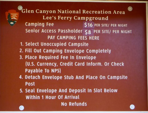
We stopped and toured the campground here for future reference as we often do.  Here’s the sign (below) if you’re interested in camping here.  It looked like there were quite a few sites that are big-rig friendly.

IMG_2836

We returned the same way we went in and snapped a few more pics of the cool rock formations:

IMG_2838

IMG_2840

IMG_2843

IMG_2845

IMG_2846

And we returned to Page after about 200 miles of driving today.  Here’s the view (below) coming in to Page from 89 south.  It was right about this time that our Wagonmaster (David Guhsé) called and asked if we could stop by Strombolli’s Restaurant to pick up the garlic bread for our spaghetti dinner.

IMG_2855

We rolled back into the campground (with garlic bread in hand) just in time for our “La Familia Spaghetti Dinner”.

IMG_2857

IMG_2860

Another awesome dinner goes off well.  Everyone enjoyed the spaghetti dinner with lots of garlic bread and salads:

IMG_2858

IMG_2862

IMG_2867

IMG_2868

IMG_2871

IMG_2874

IMG_2875

IMG_2876

IMG_2877

David even put on some “mood” music that fit the Italian theme.

IMG_2878

We were treated to an awesome sunset as we finished our dinner:

IMG_2879

IMG_2881

IMG_2882

IMG_2884

IMG_2885

IMG_2886

Hope you enjoyed today’s tour… check back tomorrow for Day 4 of our Alpine SoCal Rally.  Wish all you readers out there could join us 🙂


Antelope Slot Canyon – Alpine SoCal Rally Day 2 (Wahweap CG – Lake Powell Resort & Marina)

Welcome to Day 2 of the Alpine SoCal Lake Powell Rally 🙂

Warning! – Picture heavy post again today… consider viewing on a laptop or desktop computer since mobile devices often have trouble downloading the pictures.  Hint: If an image doesn’t load, try refreshing your screen.

We started off our day (Thursday) with a fine Alpine breakfast…

IMG_2999

courtesy of our wagon-master(s) David & Nicole Guhsé.  Here’s David boiling up some eggs to add to the already huge spread consisting of yogurts, fruits, muffins, croissants, etc.,

IMG_3004

Nicole put the finishing touches on the spread…

IMG_3010

and Lorraine Foster helped prep the tables.

IMG_3002

And then the hordes attacked 🙂

IMG_3011

IMG_3015
Breakfast with a view.

Some folks (below) took advantage of the limited time after breakfast to detail their Coach before our first scheduled activity of the day.

IMG_3019
Bob & Helena Mazzocco. (Bob seems to be doing a fine job supervising) 🙂

Our agenda for the day (below) has us meeting at the Slot Canyon Office for a tour of Antelope Slot Canyon (←click link to see more).

Lake Powell Rally Schedule

Everyone piled into their cars for the ~10 mile drive over to the Slot Canyon Office in downtown Page for our 10 AM tour.

IMG_3020

We got an extra treat while waiting for our tour to start with an Indian hoop dancer:

IMG_3026

IMG_3031

IMG_3039

IMG_3041

IMG_3053

After the entertainment, we all piled into the modified pickups for an exciting drive to the canyon…

IMG_5518

IMG_2545

It took three of these pickups to transport our large group of Alpiners.

IMG_2544

IMG_2548

We drove through a long semi-dry wash to get to the entrance.

IMG_2553

These rigs must go through a lot of springs and shock absorbers to keep them running smoothly over the rough terrain.

IMG_2559

IMG_2563

When we arrived at the entrance to the canyon, we all piled out of the pickups… no worse for wear and tear…

IMG_2566

IMG_2567

and walked to the mouth of the canyon where our driver then took over duties as tour-guide.  Each group of ~12 people had their own driver / tour-guide.

IMG_2565

We entered the canyon…

IMG_5519

and everyone said ooh and aah numerous times…

IMG_5520

Antelope Canyon was formed by erosion of Navajo Sandstone, primarily due to flash flooding and secondarily due to other sub-aerial processes. Rainwater, especially during monsoon season, runs into the extensive basin above the slot canyon sections, picking up speed and sand as it rushes into the narrow passageways. Over time the passageways eroded away, making the corridors deeper and smoothing hard edges in such a way as to form characteristic ‘flowing’ shapes in the rock.  Click HERE to learn more about this place from my friend, Wikipedia®

IMG_5521

IMG_5522

Our tour-guide / driver turned out to be quite an expert on taking photos in the canyon.  It didn’t seem to matter if it was an iPhone, Android, or expensive digital camera… she would take your picture-taking device and change the settings for the best picture.  She even took many of the cameras or phones from people and took the pictures herself.

IMG_5523

It’s hard to do this awe-inspiring place justice with pictures.  Everyone took lots of photos (us included), here’s a sampling:

IMG_2580

IMG_5528

IMG_5529

IMG_5531

IMG_5533

IMG_5535

IMG_5536

IMG_5537

IMG_5538

IMG_5539

IMG_5546

IMG_2582

IMG_2588

If anyone would like to see more pictures of the awesome place, simply send me a message and I can email the full-size originals.

Our tour-guide gathered us all together for a couple great pictures inside the canyon:

IMG_2601
Alpine SoCal group in Antelope Slot Canyon. (Lake Powell, AZ)
IMG_2603
Alpine SoCal group in Antelope Slot Canyon. (Lake Powell, AZ)

IMG_2623

We exited the canyon at the opposite end and took a short break in the sunshine while one of the Indians played a flute.

IMG_2641

IMG_2644

IMG_2647
Bob & Helena Mazzocco soaking in some sun after the cool canyon.

We backtracked through the canyon to the entrance and squeezed past the many tourists that had come in behind us.  Our nice guide made sure she didn’t lose any of us on the tour and saw us back into our seats for a return trip back to the office.

IMG_2654

Many of the Alpiners then made the short drive over to Big John’s Texas Barbecue for lunch:

IMG_2661

IMG_2662

IMG_2655

IMG_2663

IMG_2664

IMG_2658

IMG_2660

The rest of the day was basically ‘free time’ with no scheduled activities until we all gathered again at our campground for “Social Hour”.  We had some leftover pizza and garlic bread from yesterdays dinner along with assorted snacks that folks brought over.

IMG_3054

IMG_3055

We closed out another fine rally day with good conversation.  We also welcomed new members; Frank Krauland and Reginald & Karen Bodeux.  It’s always good to get new members and important for the future health of the association in order to remain strong and viable.

IMG_3056

IMG_3057

IMG_3058

I hope you enjoyed today’s tour… stay tuned for more adventure on Day 3 of our SoCal Alpine Coach – Lake Powell Rally 🙂